A sophisticated satellite-based system allows pinpointing a person’s location in a dangerous, isolated situation on land or sea. It thus hopefully speeds their subsequent rescue in many cases.
You’ve undoubtedly seen or read stories about someone miraculously recused at sea or in some relatively uninhabited, remote part of the Earth, without a way to call for help or even any sort of landmark. In many cases, the person or persons to be rescued are unconscious or in no condition to radio for help, or their radio is broken, lost power, or similar.
These successful rescues bring up two broad questions:
- How did anyone know a rescue was needed in the first place?
- How did rescuers even know where to look?
In many cases, the answers to both questions are the same: through rescue beacons and a system operated by the international Cospas-Sarsat Program, a cooperative effort of 44 member countries plus affiliated countries. This organization is dedicated to providing robust and reliable satellite-aided distress location services worldwide.
Although it is not well known to the general public, it is a widely used and well-known program and system for those in risky or potentially risky situations. Since 1982, when the first official rescue associated with the program occurred, the Cospas-Sarsat system has provided information that aided in rescuing more than 48,000 people in more than 13,000 distress situations; of that number, 9700 were in the U.S.
The Cospas-Sarsat role is simple: to determine a rescue is needed and identify where it is needed. As a result, these statistics may actually undercount the number of cases where Cospas-Sarsat provided needed information. They only include cases when an accurate report from search-and-rescue (SAR) personnel through formal reporting channels back to Cospas-Sarsat.
Note that it does not actually perform the rescue missions. In the United States, the search and rescue efforts are coordinated through the national search and rescue program called SARSAT, a combined effort between NASA and three other U.S. agencies. The actual rescue “saves” are made by the U.S. Coast Guard, U.S. Air Force, and local rescue authorities.
- The Air Force coordinates inland search and rescue.
- The Coast Guard coordinates maritime search and rescue,
- The National Oceanic and Atmospheric Administration operates the system.
NASA provides technology for the overall program to minimize the search time and maximize the rescues and has played a prominent role in designing and testing Cospas-Sarsat’s 406-MHz distress beacons, as well as the flight and ground systems that support them. The National Oceanic and Atmospheric Administration (NOAA) manages the U.S. network region for Cospas-Sarsat, which relies on flight and ground technologies developed by SAR at NASA’s Goddard Space Flight Center in Greenbelt, Maryland. NASA’s Space Communications and Navigation (SCaN) program at NASA Headquarters provides strategic oversight to the SAR office.
Why the complicated name “Cospas-Sarsat” (often spelled out with all capitals as COSPAS-SARSAT)? It’s related to the founding of the system. In 1979, a “Memorandum of understanding concerning cooperation in a joint experimental satellite-aided search and rescue project” was signed in Leningrad. Among the signers were the National Aeronautics and Space Administration, the Ministry of Merchant Marine (USSR), the Centre National d’Etudes Spatiales (France), and the Department of Communications (Canada). SARSAT is an acronym for Search And Rescue Satellite-Aided Tracking, while COSPAS is the English acronym for the Russian words “Cosmicheskaya Sistema Poiska Avariynyh Sudov,” which translates to “Space System for the Search of Vessels in Distress.”
System segments
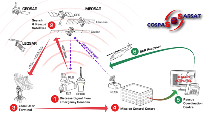
It makes sense that a system as broad in geography, complexity, and users as Cospas-Sarsat would have multiple segments and elements. Interestingly, the system integrates disparate elements, including multiple satellite systems, to provide the total coverage (Figure 1).

In the broadest sense, there are just two segments: a ground segment and a space segment. Breaking these down further, the total end-to-end system has these elements:
- Distress radio-beacons that are activated in a life-threatening emergency.
- Signal receivers, repeaters, and processors aboard satellites.
- Ground stations called local user terminals (LUTs) receive the processed data via a satellite downlink.
- Mission control centers then distribute the received distress alert data, including beacon location data if available, from the LUTs to local rescue-coordination centers (RCCs).
- Finally, the rescue coordination centers work with the local search-and-rescue agencies and personnel to respond to a distress situation.
When a beacon user (a person or vessel) is in distress, the user activates its beacon to begin the search and rescue process, or the beacon is automatically activated. When that signal is received by satellite, its signal is processed to extract useful information such as beacon I.D. and then relayed to ground station LUTs, along with data that can identify a specific location in some cases. The LUTs then use the data to calculate the beacon location. Finally, the system supplies that data and the computed location to relevant organizations and first responders across the globe.
The next part will look at the beacons in more detail.
E.E. World References
- GPS is a ubiquitous and problematic technology
- Basics of GPS receivers
- GPS, Part 1: Basic principles
- GPS, Part 2: Implementation
- Iridium global satcom system: Brilliant design, terrible business, last-minute reprieve, Part 1
- The Iridium global satcom system, Part 2: The implementation
- The Iridium global satcom system, Part 3: Very nearly crash and burn
- The Iridium global satcom system, Part 4: Lessons learned
- The Iridium global satcom system, Part 5: Advances and competition
External References
There is a lot of good information at the site of the international Cospas-Sarsat Program, especially these pages:
- Cospas-Sarsat, “Detailed Cospas-Sarsat System Description”
- Cospas-Sarsat, “What is a Cospas-Sarsat Beacon?”
- Cospas-Sarsat, “Beacon FAQ”
- Cospas-Sarsat, “What Happens When I Activate My Beacon?”
- Cospas-Sarsat, “How Do I Select and Purchase a Cospas-Sarsat Beacon?”
Other references
- NASA, “Search and Rescue (SAR) Overview”
- NASA, “NASA Develops Second-Generation Search and Rescue Beacon Technology”
- NASA, “LunaSAR: An Astronaut’s Lunar Lifeline”
- NASA, “LunaNet: Empowering Artemis with Communications and Navigation Interoperability”
- SciTech Daily, “NASA Emergency Beacons Saved 330 Lives in 2021”
- Earl Swift, Harper Collins, “Across the Airless Wilds: The Lunar Rover and the Triumph of the Final Moon Landings”
- GIFER, “Polar orbits” (Dynamic GIF)
Test-related References
- Department of Commerce/National Oceanic and Atmospheric Administration (NOAA), “Emergency Beacon Testing”
- GMD Testers, “Beacon Tester”
- W.S. Technologies Inc., “Beacon Testers”


Leave a Reply