A sophisticated satellite-based system allows pinpointing a person’s location in a dangerous, isolated situation on land or sea. It thus hopefully speeds their subsequent rescue in many cases.
Cospas-Sarsat uses three types of satellites: low-Earth orbit search-and-rescue (LEOSAR), medium-Earth orbit search-and-rescue (MEOSAR), and high-altitude geosynchronous orbit search-and-rescue (GEOSAR satellites). There are five LEOSAR, seven GEOSAR, and more than 35 MEOSAR satellites in operation. This is unlike a GNSS such as GPS or a communications system such as Iridium which use a single type of satellite in a dedicated constellation.
In fact, the Cospas-Sarsat satellites are not single-purpose dedicated satellites. Instead, the needed circuitry and system is built into a larger satellite and typically is attached to a satellite launched primarily for another purpose. This reduces launch effort, costs, satellite tracking and operations effort, and more. The primary mission of all of the LEOSAR and GEOSAR satellites is meteorological, while the primary mission of all of the MEOSAR satellites is navigation.
All these satellites need to be tracked and listened to at all times since the occurrence of a beacon signal is a random event. There are 65 ground stations local user terminals tracking LEOSARs, 31 tracking GEOSARs, and 17 tracking MEOSARs.
When a distress beacon is activated, the Cospas-Sarsat system performs these actions:
- It performs complex mathematical analyses of the signal to calculate the beacon’s location, even if it is not reported in the distress message. It does this by using the Doppler effect knowledge of the satellite’s orbital track and more.
- It also decodes the beacon’s message, which contains information such as the identity of the vessel/aircraft. For beacons equipped with a GNSS feature, it also decodes this position. Note that doing this provides redundancy regarding the first action, which may have excessive positional uncertainty due to even minor signal issues or algorithm subtleties.
The LEOSAR satellites
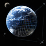
A single polar-orbit satellite can monitor the Earth’s entire surface without gaps, but it takes 24 hours as the Earth rotates below the satellite. However, by using a larger number of polar-orbit satellites, the entire Earth surface can be covered simultaneously, with the number needed determined by the coverage spread of each one. The LEOSAR constellation uses polar-orbiting satellites rather than the more-common equatorial or inclined-plane orbit, an orbital plane that yields a “strong” Doppler effect in the up-link signal (Figure 1).
This is used to provide detailed positioning/location information of the signal’s source. Otherwise, without GNSS information from the beacon, all the satellite could indicate was that there was a beacon signal in its area of coverage and timestamp when the signal was received, which is a fairly rough indication.
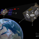
The algorithms which use the Doppler effect enable determination of both bearing and range with respect to the satellite, based on not only the change in the received frequency but also its rate of change, which is a function of both according to the path of the satellite in space and the rotation of the Earth. When the satellite receives beacon signals, the on-board Search and Rescue Processor (SARP) recovers the digital data from the beacon signal, measures the Doppler frequency shift, and time-tags the information.
In “local” mode, this result is transferred immediately to the satellite downlink for transmission to any LEOSAR LUT in view. This data is also stored on the spacecraft for later transmission and ground processing in the global coverage mode. The stored data is continuously broadcast on the satellite downlink in global mode. Therefore, each beacon can be located by all LEO LUTs that track the satellite (even for LEOLUTs that were not in the satellite’s footprint when the beacon was detected by the satellite). This provides global coverage and introduces ground-segment processing redundancy.
The ability to determine position via Doppler-shift algorithms was especially important before many beacons incorporated GNSS capability and could relay those coordinates to the satellites. It is still needed as in some situations, such as a hiker in a canyon, the beacon may not have simultaneous visibility to the four GNSS satellites required to provide a precise position fix or even three for a coarse fix. However, in the many cases where the beacon can also send GNSS coordinates, the search and rescue operation is simplified and speeded up since the “search” effort is reduced so the team can focus on “rescue” – and time to rescue is critical in many of these emergencies.
The GEOSAR satellites
The GNSS constellations (the array of satellites in the specific GNSS) also listen for beacon signals. Since GEOSAR satellites remain in fixed positions relative to the Earth, there is no Doppler effect on the received frequency. Therefore, the Doppler positioning technique cannot locate distress beacons. Instead, the beacon location must be provided via the beacon as provided by an internal or an external GNSS receiver (and encoded in the beacon message.
The GEOSAR and LEOSAR system search and rescue capabilities are complementary and not in functional conflict. Their orbital paths are roughly at right angles and thus provide better coverage with respect to overlaps, redundancy, and other operational enhancements (Figure 2).
For example, while the GEOSAR system can provide almost immediate alerting in the footprint of the GEOSAR satellite, the LEOSAR system can:
- provide excellent coverage of the polar regions (beyond the coverage of geostationary satellites).
- calculate the location of distress events using Doppler-processing algorithms and techniques.
- offer less susceptibility to obstructions which may block a beacon signal in a given direction because the satellite is continuously moving with respect to the beacon.
The next part concludes this article with a look at the most recent enhancement to Cospas-Sarsat and NASA’s exploration of a similar system for use by lunar explorers.
EE World References
- GPS is a ubiquitous and problematic technology
- Basics of GPS receivers
- GPS, Part 1: Basic principles
- GPS, Part 2: Implementation
- Iridium global satcom system: Brilliant design, terrible business, last-minute reprieve, Part 1
- The Iridium global satcom system, Part 2: The implementation
- The Iridium global satcom system, Part 3: Very nearly crash and burn
- The Iridium global satcom system, Part 4: Lessons learned
- The Iridium global satcom system, Part 5: Advances and competition
External References
There is a lot of good information at the site of the international Cospas-Sarsat Program, especially these pages:
- Cospas-Sarsat, “Detailed Cospas-Sarsat System Description”
- Cospas-Sarsat, “What is a Cospas-Sarsat Beacon?”
- Cospas-Sarsat, “Beacon FAQ”
- Cospas-Sarsat, “What Happens When I Activate My Beacon?”
- Cospas-Sarsat, “How Do I Select and Purchase a Cospas-Sarsat Beacon?”
Other references
- NASA, “Search and Rescue (SAR) Overview”
- NASA, “NASA Develops Second-Generation Search and Rescue Beacon Technology”
- NASA, “LunaSAR: An Astronaut’s Lunar Lifeline”
- NASA, “LunaNet: Empowering Artemis with Communications and Navigation Interoperability”
- SciTech Daily, “NASA Emergency Beacons Saved 330 Lives in 2021”
- Earl Swift, Harper Collins, “Across the Airless Wilds: The Lunar Rover and the Triumph of the Final Moon Landings”
- GIFER, “Polar orbits” (Dynamic GIF)
Test-related References
- Department of Commerce/National Oceanic and Atmospheric Administration (NOAA), “Emergency Beacon Testing”
- GMD Testers, “Beacon Tester”
- WS Technologies Inc., “Beacon Testers”

Leave a Reply