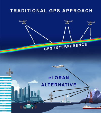
Terrestrial-based hyperbolic navigation technologies predate today’s satellite-based global positioning system (GPS). Starting with developments in the 1930s and 1940s, land-based long-range navigation (LORAN) systems using hyperbolic navigation have been continuously advanced. Today, the enhanced LORAN (eLORAN) system has been offered a more secure alternative to GPS.
Hyperbolic navigation technologies were independently developed in the U.S. and the U.K during World War II. The Gee system was developed in the U.K. and used by the Royal Air Force. It measured the time delay between two radio signals to produce a location, with accuracy on the order of a few hundred meters at ranges up to about 350 miles (560 km). The first hyperbolic navigation system was to be used operationally, entering service with RAF Bomber Command in 1942.
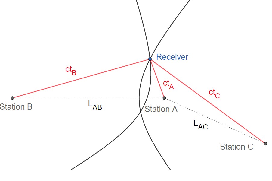
In the figure above, the three ground stations A, B, C, have known locations. The times it takes for a radio signal to travel from the stations to the receiver are unknown, but the time differences are known. That is, tA, tB, tC is unknown, but tA – tB and tA – tC are known. Each time difference can be used to locate the receiver on a hyperbola branch focused on the ground stations. The receiver is then located at one of the two intersections. Other navigation information can be used to determine at which intersection the receiver is located.
Gee inspired the original LORAN system developed in the U.S. LORAN was similar to the Gee system. Still, it operated at lower frequencies to provide an improved range up to 1,500 miles (2,400 km) with an accuracy of tens of miles. It was first used for ship convoys crossing the Atlantic Ocean, and then by long-range patrol aircraft, but found its main use on the ships and aircraft operating in the Pacific theater during World War II.
Early LORAN equipment was expensive, limiting its use to military and large commercial users. With advanced electronics, system costs came down, and automated receivers became available. The third-generation called LORAN-C became available and offered a longer range and location accuracy of a few tens of feet. As a result of advances in microelectronics, LORAN-C receivers dropped significantly in price, and earlier generations of LORAN were mostly abandoned.
Hyperbolic navigation and the Decca system
The Decca system for hyperbolic navigation was invented in the U.S., but development was carried out in the UK. The Decca Navigator System was a hyperbolic radio navigation system that allowed ships and aircraft to determine their position by receiving radio signals from fixed navigational beacons. The system used a phase comparison of two low-frequency signals between 70 and 129 kHz, as opposed to pulse timing systems like Gee and LORAN. This made it much easier to implement the receivers using 1940s electronics.
And, unlike LORAN, Decca was not known to the Germans and thus free of jamming. After the war, it was extensively developed around the UK and later used in many areas worldwide. Decca’s primary use was for ship navigation in coastal waters, offering much better accuracy than the competing LORAN system. The opening of the more accurate Loran-C system to civilian use in 1974 offered stiff competition, but Decca was well established by this time and continued operations into the 1990s. Decca was eventually replaced, along with Loran and similar systems, by satellite-based GPS during the 1990s.

Enter enhanced LORAN
Enhanced LORAN (eLORAN) is the 21st-century evolution of LORAN-C, which was operational for over 60 years. A trusted positioning, navigation, and timing system initially developed during World War II, LORAN-C provided long-range and highly accurate wireless signals supporting navigation for aircraft and maritime applications globally. Improved over the last 20 years, eLORAN utilizes the same low frequency, high power radio signals transmitted from land-based towers. With reported accuracy as good as ± 8 meters, the system is competitive with unenhanced GPS. eLORAN also includes additional pulses which can transmit auxiliary data such as Differential GPS (DGPS) corrections, as well as ensure data integrity against spoofing.
A single tower provides users with a highly accurate timing signal, and with 3 towers “in view,” a user device can derive its 2D location (latitude and longitude). Transmitting at 90-110 kilohertz and operating on a digital channel, eLORAN exceeds the accuracy, availability, integrity, and continuity performance requirements for all modern PNT applications. eLORAN is difficult to spoof or jam, and it is nearly impossible to do so at a distance. Just as equipment required to spoof and jam GNSS and GPS must mimic relatively low powered transmissions, spoofing and jamming eLORAN requires very high-powered transmissions.
eLORAN also utilizes differential corrections to improve accuracy over the LORAN-C system significantly. Much like Differential GPS/GNSS (DGPS/GNSS), differential monitoring reference stations can be deployed across the nation. These reference stations receive the raw eLORAN signals from the main transmitting towers, detect any deviations and send corrections back to the eLORAN towers. The eLORAN towers then transmit the corrections via the LORAN data channel (LDC) in the main eLORAN signal to all users, substantially improving PNT accuracy.
In addition to improving accuracy, the LDC brings a unique capability to all eLORAN customers: The ability to send one-way data communication signals for any customer need. These data commands can penetrate buildings, underground significantly, and underwater, providing a unique and powerful command and control capability.
eLORAN capabilities include:
- The signal is 3-5 million times stronger than GPS/GNSS
- 99.999% reliability & availability
- 1,200-mile signal range
- Transmitted at up to 1 MW of power and nearly impossible to disrupt, jam, or spoof
- Spectrum: 90 kHz to 110 kHz internationally protected
- Usable anywhere, penetrates all buildings, structures, tunnels, underground, underwater w/without amplification
- Added encryption and authentication make eLORAN spoof-proof
- Synchronized to Universal Coordinated Time (UTC)
- Supports unmanned/autonomous operations (low cost)
- Terrestrial, independent but interoperable with GPS/GNSS
- Required infrastructure for US national coverage: 6 towers for timing, 19 for position & navigation
- User antenna integrated with a receiver, no need for roof or external installations
Pentagon ordered to find GPS replacement
eLORAN is expected soon to have competition as a possible replacement for GPS. There are numerous efforts to develop the so-called “assured position, navigation, and timing” (APNT) systems. APNT systems are designed to compensate for any loss of GPS signals and provide multiple alternative sources of data that can validate existing GPS data’s trustworthiness.
As a result of the growing vulnerability of GPS to jamming and spoofing (for a discussion of GPS vulnerabilities, you can read part one of this FAQ series, “GPS is a ubiquitous and problematic technology”), the U.S. Senate Armed Services Committee (SASC) has ordered the Pentagon to provide an alternative to GPS within two years. In Section 1601 of the 2021 National Defense Authorization Act (NDAA), SASC states that the two-year deadline is “consistent with” urgent needs, and the Pentagon must:
- Prioritize and rank order the mission elements, platforms, and weapons systems most critical for the operational plans of the combatant commands;
- Mature, test, and produce for such prioritized mission elements sufficient equipment —
- to generate resilient and survivable alternative positioning, navigation, and timing signals; and
- to process resilient, survivable data provided by signals of opportunity and on-board sensor systems; and
- Integrate and deploy such equipment into the prioritized operational systems, platforms, and weapons systems.
The third and final FAQ in this series, “Quantum compasses and optical imaging for global positioning and navigation,” will present several advanced technologies proposed as unhackable and unjammable GPS replacements for providing PNT.
Resources:
Decca Navigator System, Wikipedia
eLORAN, a Resilient Complement to GPS/GNSS, Hellen Systems
eLORAN transmission systems, Continental Electronics
Hyperbolic navigation, Wikipedia


The NDAA 2021 section referred to isn’t 1601; it’s 1611.
The article states that eLoran features “999% reliability and availability”. That sounds like a missed decimal point. Shouldn’t it read “99.9%”? How can a system be nearly 10 times its potential reliability?
You are absolutely right, Michael. Thanks for pointing that out and we have fixed it. Cheers, Aimee
“Usable anywhere, penetrates all buildings, structures, tunnels, underground, underwater w/without amplification”
—-
Maybe in theory but apparently not in practice on recently demo’d systems to the us-dot.
Jan 2021 report to congress – Complementary PNT and GPS Backup Technologies Demonstration Report
https://www.transportation.gov/administrations/assistant-secretary-research-and-technology/complementary-pnt-and-gps-backup
In the results it shows the two vendors submitting eLORAN systems (Hellen Systems and UrsaNav) both had no signal in a basic basement.